


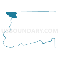
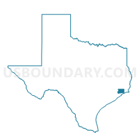
Voting District 0004, Chambers County, Texas
About
Outline

Summary
| Unique Area Identifier | 671443 |
| Name | Voting District 0004 |
| County | Chambers County |
| State | Texas |
| Area (square miles) | 25.56 |
| Land Area (square miles) | 24.93 |
| Water Area (square miles) | 0.63 |
| % of Land Area | 97.54 |
| % of Water Area | 2.46 |
| Latitude of the Internal Point | 29.85478690 |
| Longtitude of the Internal Point | -94.90392140 |
Maps

Graphs
Select a template below for downloading or customizing gragh for Voting District 0004, Chambers County, Texas


Neighbors
Neighoring Voting District (by Name) Neighboring Voting District on the Map
- Voting District 0005, Chambers County, TX
- Voting District 0008, Chambers County, TX
- Voting District 0010, Chambers County, TX
- Voting District 0011, Chambers County, TX
- Voting District 0022, Liberty County, TX
- Voting District 0024, Liberty County, TX
- Voting District 0103, Harris County, TX
- Voting District 0386, Harris County, TX
Top 10 Neighboring County Subdivision (by Population) Neighboring County Subdivision on the Map
- Baytown CCD, Harris County, TX (72,734)
- Northeast Harris CCD, Harris County, TX (59,937)
- Liberty-Dayton CCD, Liberty County, TX (41,322)
- Mont Belvieu CCD, Chambers County, TX (22,045)
Top 10 Neighboring Place (by Population) Neighboring Place on the Map
Top 10 Neighboring Unified School District (by Population) Neighboring Unified School District on the Map
- Goose Creek Consolidated Independent School District, TX (99,072)
- Dayton Independent School District, TX (28,170)
- Crosby Independent School District, TX (24,689)
- Barbers Hill Independent School District, TX (14,411)
Top 10 Neighboring State Legislative District Lower Chamber (by Population) Neighboring State Legislative District Lower Chamber on the Map
- State House District 18, TX (150,998)
- State House District 128, TX (148,817)
- State House District 23, TX (144,933)
Top 10 Neighboring State Legislative District Upper Chamber (by Population) Neighboring State Legislative District Upper Chamber on the Map
Top 10 Neighboring 111th Congressional District (by Population) Neighboring 111th Congressional District on the Map
Top 10 Neighboring Census Tract (by Population) Neighboring Census Tract on the Map
- Census Tract 7102, Chambers County, TX (15,543)
- Census Tract 2532, Harris County, TX (9,429)
- Census Tract 2531, Harris County, TX (8,439)
- Census Tract 7011, Liberty County, TX (6,954)
- Census Tract 7101, Chambers County, TX (6,502)
- Census Tract 7010, Liberty County, TX (6,216)
- Census Tract 2528, Harris County, TX (5,882)